Recently, Dapeng Yuan, a doctoral student of School of Oceanography, Shanghai Jiao Tong University (SJTU-SOO), published a research paper titled “Remote sensing of seawater optical properties and the subsurface phytoplankton layer in coastal waters using an airborne multiwavelength polarimetric ocean lidar” in Optics Express as the first author. The first author affiliation of the paper was Shanghai Jiao Tong University, and the co-correspondence authors was Zhihua Mao, the double-employed professor of SJTU-SOO. The co-authors of the paper included Academician Delu Pan, the double-employed professor of SJTU-SOO, Associate Researcher Peng Chen of the State Key Laboratory of Satellite Ocean Environment Dynamics, and Researcher Yan He of the Shanghai Institute of Optics and Fine Mechanics, Chinese Academy of Science.
Coastal waters account for only approximately 7% of the global ocean surface and only 0.5% of the total seawater volume. However, as the transition zone between terrestrial environments and the open ocean, coastal waters play important roles in terms of biogeochemical cycles, global air–sea CO2 exchanges, coastal habitats, fish species, and human activities. Given the growing concerns about the degradation of coastal marine ecosystems caused by land-based activities, the long-term investigation and monitoring of coastal marine environments are highly warranted, and the outcomes should help environmental protection departments better formulate policies for coastal marine governance. The light detection and ranging (lidar) method, an active remote sensing technology, has been widely applied in various oceanographic fields because of its remarkable advantages, namely, its ability to acquire continuous day-night observations, its high spatiotemporal resolution, and the penetrability of ocean waters by lidar-emitted laser pulses; examples of shipborne and airborne lidar applications include research on seawater optical properties, the subsurface phytoplankton layer, fish schools, the speed of sound in seawater. The vertical profiles of coastal waters obtained by lidar can help monitor the coastal marine environment. However, coastal waters are more sophisticated than open ocean waters due to the influences of terrestrial inorganic and organic carbon inputs, which also make it challenging for lidar systems to detect the profile properties of coastal waters.
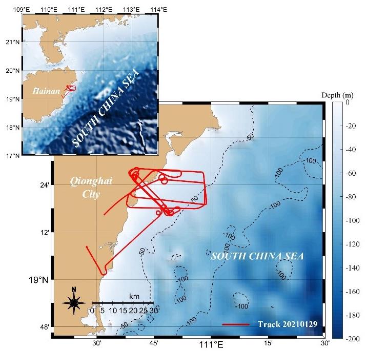
Fig. 1. Map of the South China Sea (SCS) with the flight track shown in red.
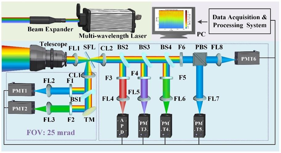
Fig. 2. Schematic of the airborne multiwavelength polarimetric ocean lidar system.
The flight experiment with the airborne multiwavelength polarimetric ocean lidar system took place on January 29, 2021. The aircraft flew approximately 300–600 m above the sea surface, and the detailed flight track in the context of the study region is shown in Fig. 1. The optical properties and subsurface phytoplankton layer in coastal waters were observed using an airborne multiwavelength polarimetric ocean lidar developed by the Shanghai Institute of Optics and Fine Mechanics (SIOM), Chinese Academy of Sciences. The airborne lidar system comprises a multiwavelength laser emission subsystem, a receiving subsystem, an optical processing and detecting subsystem, and a data acquisition and processing subsystem, as shown in Fig. 2.
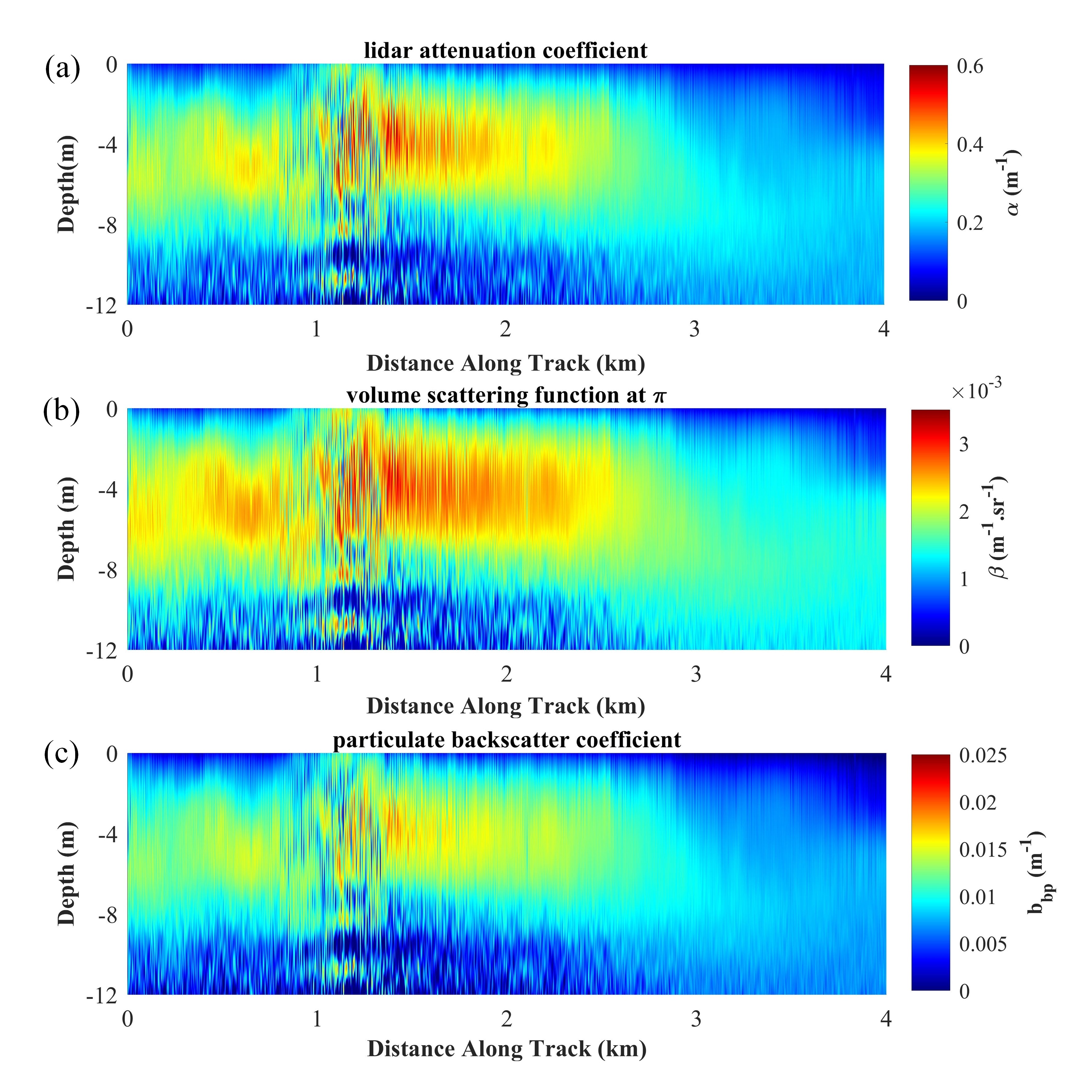
Fig. 3. Vertical profile distribution of the seawater optical profiles along the lidar flight track.
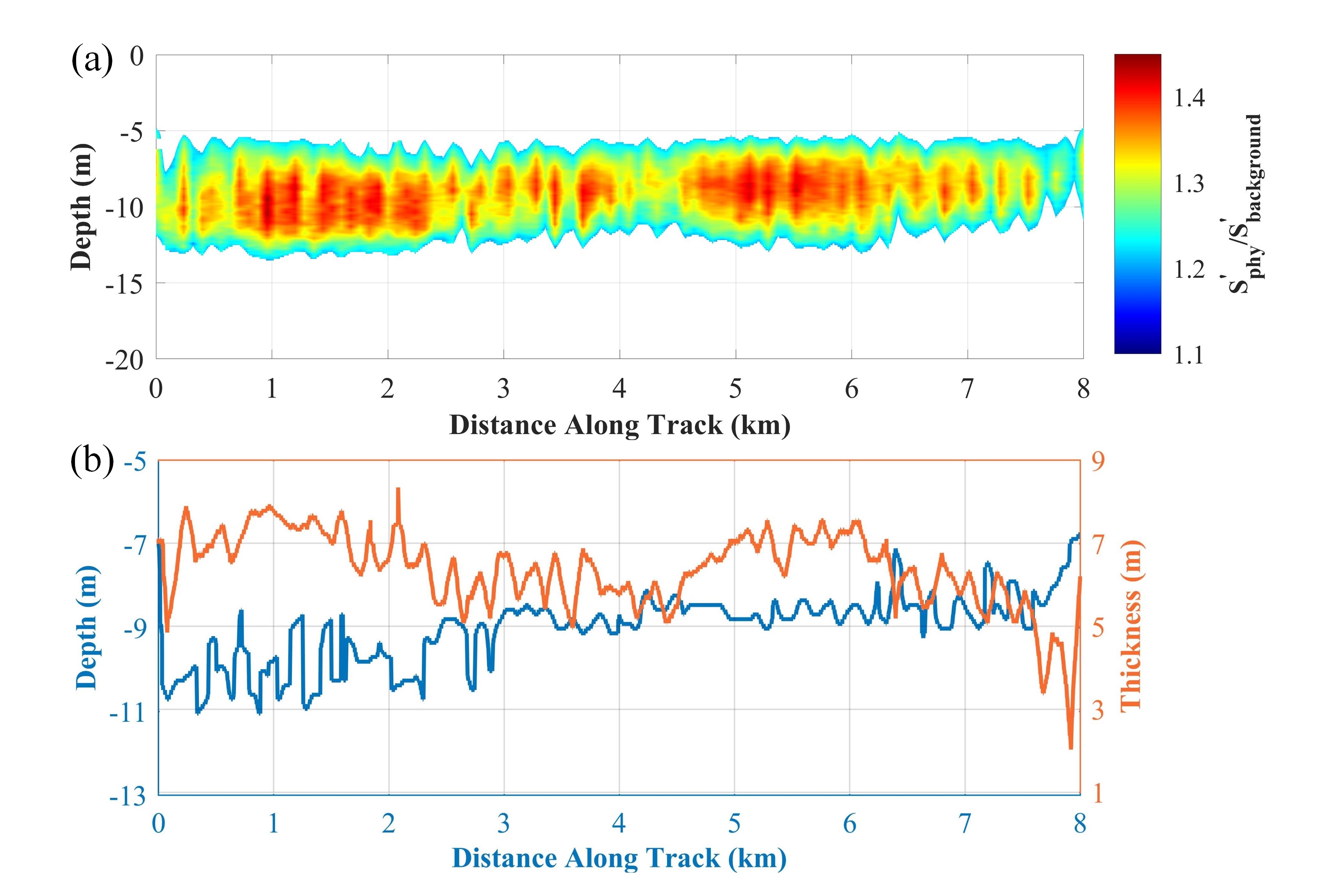
Fig. 4. Vertical profile distribution of the subsurface phytoplankton layer in the coastal waters along the lidar flight track.
In this research, the vertical profile distributions of seawater optical properties and the subsurface phytoplankton layer observed using airborne lidar in the coastal waters near Qionghai city were studied. The vertical stratification of seawater optical properties along a flight track from 19.19°N to 19.27°N is more pronounced than that from 19.27°N to 19.31°N. Moreover, the subsurface phytoplankton layer is distributed along the lidar flight track at water depths ranging from 5–14 m, and its thickness varies from 2 m to 8.3 m; the reason for this phenomenon may be that light and nutrients are sufficiently supplied simultaneously at water depths of 5–14 m, which promotes phytoplankton growth. Additionally, the high concentrations of chlorophyll, CDOM, and SPM in coastal waters are the main factors leading to the shallower detection depth of the airborne lidar, and the lower laser incident energy at 486 nm in the flight experiment is the primary reason for the loss of lidar signal at 486 nm. This study provides a new technical idea for quantitative inversion of different components in coastal waters based on multi-channel data at different wavelengths obtained from the airborne multiwavelength polarimetric ocean lidar system. These finding indicate that lidar technology has great potential for the wide-range and long-term monitoring of coastal waters, the outcomes of which can help environmental protection departments better formulate policies for coastal marine governance in the future.
Link to the article: https://doi.org/10.1364/OE.463146