Recently, Zhengyi Wang, a doctoral student of School of Oceanography, Shanghai Jiao Tong University (SJTU-SOO), published a research paper titled “Observations of the Impacts of Hong Kong International Airport on Water Quality from 1986 to 2022 Using Landsat Satellite” in Remote sensing as the first author. The first author affiliation of the paper was Shanghai Jiao Tong University, and the co-correspondence author was Zhihua Mao, the double-employed professor of SJTU-SOO. The co-authors of the paper included doctoral student Longwei Zhang from Zhejiang University, doctoral student Xianliang Zhang from Shanghai Institute of Technical Physics, Chinese Academy of Sciences, doctoral student Dapeng Yuan from Shanghai Jiao Tong University, doctoral student Youzhi Li from Nanjing University, Associate Professor Zhongqiang Wu from Hainan Normal University, and Senior Engineer Haiqing Huang and Senior Engineer Qiankun Zhu from the Second Institute of Oceanography, Ministry of Natural Resources.
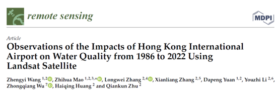
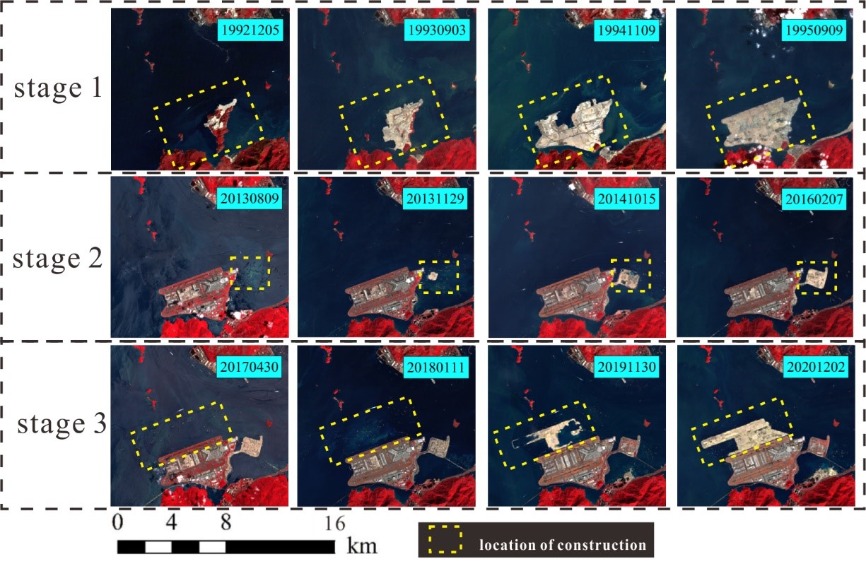
Figure 1. Monitoring of the three stages of construction activity at HKIA.
With the increase in the population, social modernization is accelerating unpredictably. The contradiction in the form of more people and less land is becoming increasingly prominent. To address the lack of available land, one of the critical methods of increasing land area in many countries is reclamation. In modern society, there is an increase in nearshore and offshore engineering, which inevitably pollutes the marine environment and influences water quality. Hong Kong International Airport (HKIA) is an important sea airdrome in China. And it is one of the busiest airports in the world, ranking fifth in passenger traffic and first in cargo traffic in the world. In this study, 117 Landsat 5 TM and 44 Landsat 8 OLI images were used to observe the reclamation of HKIA, and the reclamation was divided into three stages :(1) the construction of the first and second runways from 1992 to 1995; (2) the construction of the Hong Kong Port from 2013 to 2016; and (3) the construction of the third runway from 2017 to 2020. (Figure 1).

Figure 2. Correlations between in situ values and estimated values for Landsat 5. (a) SPM;(b) PO4P;(c) DIN.
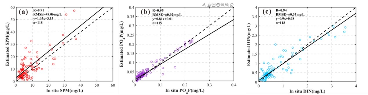
Figure 3. Correlations between in situ values and estimated values for Landsat 8. (a) SPM; (b) PO4P;(c) DIN.
In order to assess the impact of HKIA on water quality, this study matched 161 satellite images with in situ water quality data in time and space. Based on machine learning theory, the retrieval algorithms of suspended sediment (SPM), orthophosphate (PO4P) and dissolved inorganic nitrogen (DIN) were established for Landsat 5 TM and Landsat 8 OLI satellite sensors using BPNN. For Landsat 5 TM (Figure 2), the R values of SPM, PO4P and DIN algorithms were 0.8, 0.8 and 0.84, and the RMSE values were ±10.72 mg/L, ±0.09 mg/L and ±0.82 mg/L, respectively. For Landsat 8 OLI (Figure 3), the R values of SPM, PO4P and DIN algorithms were 0.91, 0.95 and 0.94, respectively, and the RMSE values were ±9.06 mg/L, ±0.02 mg/L and ±0.35 mg/L, respectively. Relevant parameters show that the remote sensing retrieval algorithms established in this area have good accuracy, which also indicates that BPNN and other machine learning methods have high applicability in establishing remote sensing algorithms for nearshore water bodies.

Figure 4. Spatial distributions of SPM in the vicinity of HKIA from 1986 to 2022.
Based on the remote sensing retrieval algorithms of water quality indicators established for two satellite sensors, this study retrieved the concentrations of SPM, PO4P and DIN of waters in the vicinity of HKIA from 1986 to 2022. Figure 4 shows the spatial distribution of SPM. Combining the analysis of satellite data and in situ data, it is found that the concentration of SPM in the construction area increased dramatically to 40-50 mg/L during the reclamation, and the concentrations of PO4P and DIN also increased correspondingly. In order to assess the impact of the construction of HKIA on water quality quantificationally, this study calculated the deviation factor among the water quality indicators of the internal water body of the bay, the input of the Tuen Mun River and the external water body of the west side of the bay. The results showed that due to the construction of the HKIA, the flow of the Tung Chung River was intercepted, while the impact of the input of the Tuen Mun River on the internal water body of the bay gradually increased (The SPM deviation factor decreased from 0.82 to 0.18). Due to the expansion of reclamation, the external transportation of the west side of the bay has been intercepted more and more obviously, and the SPM deviation factor between the internal and external waters of the bay has increased from 0.09 to 0.78. In this study, satellite observation was carried out on the reclamation of Hong Kong International Airport, and the retrieval algorithms of water quality indicators of nearshore water was established based on BPNN and the retrieval results were analyzed comprehensively. This study provides a new research method for assessing the impact of large-scale Marine traffic engineering on water quality and provides a scientific basis for the protection and utilization of the surrounding marine environment of Hong Kong.
This work was supported in part by the National Science Foundation of China under Grant 61991454, in part by the Major Project of High-Resolution Earth Observation Systems of National Science and Technology under Grant 05-Y30B01-9001-19/20-2, and in part by the National Key Research and Development Program of China under Grant 2016YFC1400901.
Link to the article:
https://doi.org/10.3390/rs15123146